Go to Math Dept Main Page | Go to Mission College Main Page
This paper was written as an assignment for Ian Walton's Math G -Math for liberal Arts Students - at Mission College. If you use material from this paper, please acknowledge it.
To explore other such papers go to the Math G Projects Page.
In a world of El Ninos, Devastating hurricanes, exploding Volcanoes, and ever-increasing automobile emissions, it‰s easy to become an alarmist. We can imagine vague monsters like the Greenhouse Effect melting the icecaps and increasing temperatures around the globe to unbearable heights. We can lay awake at night thinking about water shortages in Southern California, or coastal communities crashing into the sea as the waves advance. Or we can turn to mathematics and actually figure out just exactly what‰s going on in this world of ours. How rapidly is the atmosphere warming? When will there be another El Nino? Where will it be safe for us to raise a family, without fear of flood, famine, or pestilence?
In 1982 scientists predicted an El Nino event. The general consensus among those who knew was that the El Nino for that year would be relatively mild. No one was concerned. No one prepared. The El Nino of 1982 proved to be an extremely large, long, angry beast that devastated unprepared communities the world over, causing many billions of dollars in storm damage, and costing many their lives. Why was this event not properly predicted, and how can we be more prepared in the future?
The answer to these and many other questions may lie in the mathematical science of Climate Modeling. In Climate Modeling, scientists collect data from various parts of the world and input it into a computer software program that takes the data and models the climate. Adjusting certain variables, like the amount of carbon dioxide we put into the air each year, they can re-run the simulation and model what the atmosphere and our climate will look like in years to come.
It turns out that the problem scientists faced in 1982 was a lack of sufficient data to plug into their system. The process of collecting this data is extremely complex and costly, but the benefits our civilization can reap far outweigh these factors.
A model can be simple or complex. It can be a physical, tangible thing, or an abstract representation of the thing it is modeling. An example is the model car you may have built as a child. The model car is designed to look like the real car it is modeled after, except that it is constructed out of materials like glue and plastic that are easier for a twelve year old to work with than steel and a blowtorch. And usually the model car is built to scale, but is smaller than the original. Climate models follow the same general principles. A climate model is usually depicted as an image or a graph, constructed of meticulously collected data representing the real or potential conditions in the atmosphere.
Because of the sheer vastness of the data required to generate a reliable and useable climate model, computers are necessary. Computers are able to execute huge numbers of calculations each second, reducing a mathematical task that would take a human many years down to a manageable time frame of a few hours. Even computers find this task challenging, and high-end workstations and supercomputers like the Cray are required to do the job.
The NCAR Scientific Computing Division displays sample models at their Web site: http://www.scd.ucar.edu/vg/. The two samples reproduced here model Greenhouse Warming and Sulfate Aerosols, first as a static image and then as a video which shows change over time:
The primary source of data for a climate model will come from the many hundreds of meteorological stations around the world. Besides stations on the ground, scientists collect data from scientific instruments that monitor the earth from satellites orbiting the planet, from aircraft that can sometimes fly directly into a storm, from ships and buoys that float on the surface of the ocean, and instrumentation submerged at varying depths beneath the sea.
Each meteorological station measures local weather conditions like temperature, precipitation, and wind. Each of these data points can be fed into the model, or used for local weather reporting or forecasting. Today, technology allows us to access more information faster. We can now use the Web to find the weather anywhere in the country by typing in a zip code (The Weather Channel)
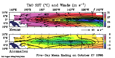
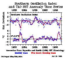
One of the difficulties facing scientists, as demonstrated in the 1982 El Nino forecasting disaster, is the lack of reliable data from remote and inaccessible areas. In 1982, there were not enough stations collecting data from the Pacific Ocean. This is being remedied by the deployment of huge fleets of buoys that measure conditions on the surface and trail miles long lengths of cable underneath them to measure conditions deep in the ocean. These buoys are sometimes lost in storms, may sink, or may be vandalized by local fishermen, who sometimes illegally relocate the buoys to use them as fish lures. The National Oceanographic and Atmospheric Administration (NOAA) is a United States government agency. They have a project which deploys these buoys. The Tropical Atmosphere-Ocean Array (TAO) consists of almost 70 moored bouys spanning the equatorial Pacific Ocean. These buoys send signals consisting of the following data to orbiting satellites:
Each night, scientists download this information from the satellites, and feed the information into their climate models. The information can be displayed as a mathematical graph, as illustrated in these examples from the TAO project Web page:
Data to predict future climate and atmospheric conditions comes from various sources. Scientists can model the deterioration of the ozone layer by measuring the introduction of carbon dioxide into the atmosphere. The potential benefits of legislation controlling emissions can be modeled, as can the effects of a volcanic explosion or other natural phenomenon.
Much can be learned by studying the past. By looking at trends that have brought us to our current place, we can better understand the world we live in now and where we are going in the future. Climatologists at the University of Massachusetts collected data from various sources to model the climate, reconstructing global temperatures for the past 600 years (see http://www.umass.edu/newsoffice/press/98/0422cli.html for the source of this information). Although weather instruments have only been used for the last 150 years or so, our resourceful climatologists found reliable data from many other sources, such as:
Using this data, scientists were able to gain a view of our world heretofore hidden from view.
Scientists interested in learning more about the atmosphere by creating climate models can use software like Climate System Model (CSM) created by NCAR. NCAR states that CSM is a fully-coupled, global climate model that provides state-of-the-art computer simulations of the Earth's past, present, and future climate states. CSM models data collected from the atmosphere, the ocean, the land, and sea ice at the polar ice caps. Scientists conduct experiments by inputting various kinds of scenarios as data. CSM will output data in various forms readable by other graphics and analysis software. For example, scientists can predict how much the atmosphere will warm up because of carbon dioxide in a 120 year period (source: http://www.scd.ucar.edu/vg/CSM/CSM.html):
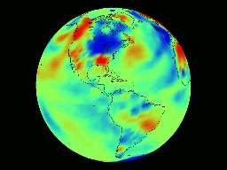
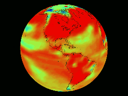
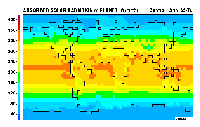
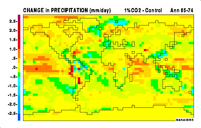
At NASA's Goddard Institute for Space Studies, scientists have developed General Circulation Models of earth's atmosphere and climate. These are computer models that numerically solve fundamental equations describing the conservation of mass, energy, momentum, etc. The GCMs are all Cartesian grid-point models which can be run at a variety of horizontal and vertical resolutions; e.g., 8Á×10Á, 4Á×5Á, or 2Á×2.5Á in the horizontal (latitude × longitude) and nine-layer, eighteen-layer, 23-layer, and 31-layer in the vertical (http://www.giss.nasa.gov/research/modeling/gcms.html).
Using these techniques, scientists can model the climate. Here are some pictures output from these climate models. These were generated by a CGI program at http://www.giss.nasa.gov/data/caom/:
This paper was written as an assignment for Ian Walton's Math G -Math for liberal Arts Students - at Mission College. If you use material from this paper, please acknowledge it.
![GIF Image [640x320, .13 MB]](co2.gif)